Calgary Flood

If you follow any mass media news, you’ve probably heard about the flooding in Calgary caused by high water volumes in the Bow and Elbow rivers. The rivers join together in the downtown heart of Calgary, where most businesses were shuttered during the worst of the flooding. However, many residents along the rivers were also significantly impacted with lost homes and property. My family has been exceedingly fortunate, only my son’s and my bicycle routes to work have been affected.

In order to bicycle from our home (on the west side of the Bow) to our work (on the east side), there used to be a choice of five bridges – with commute times ranging from 50 minutes to 2 hours depending on the route and bridge. Today, only one of the bridges remains navigable, but the commute is still less than an hour and a half. The bridges themselves do not appear to have been significantly damaged, but the surrounding landscape and pathways leading to the bridges may be forever altered.

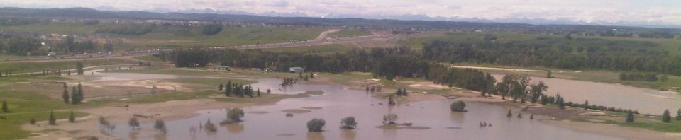
Here is the McKenzie Meadows golf course (close to the south end of Calgary),  5 days after the start of the flood. The photo was taken looking west, with the Bow River and Rocky Mountains in the background.

mackenzie-golf-course-960x198.jpg

New Header Photo – Winter Biking

The new header photo of me was taken by Ian Goodman, a photographer and equally avid winter cyclist, on a recent ride in Fish Creek Provincial Park. Ian’s been experimenting with the panorama feature on his iPhone, and I think it looks great! Thanks Ian!

(C) Ian Goodman

Bicycling to Calgary Agile Methods Users Group

I biked yesterday to the University of Calgary from the Chinook C-Train station to attend a meeting of the Calgary Agile Methods Users Group. I was glad I made it, because there was a stimulating group discussion with attendees contributing from their own team experiences.

Here’s the route I took, starting at the Chinook c-Train Station parking. Getting on to the pathway system at Chinook Center, I haded for Glenmore Dam, north to the Bow River pathway, and then past Foothills Hospital to the U of C. On the way back, I had intended to ride from the U of C to get home quick, but couldn’t leave the Hillhurst / Sunnywide Station because of an accident on the tracks downtown. After waiting a few moments, I left the train on bike (other passengers were starting to eye my bike with envy, so I got going while the going was good). I first thought I’d catch another train at the east end of downtown, but it was a warm clear night and with summer biking rapidly drawing to a close, I headed for Chinook with Google Maps as my guide.

Calgary SE / NW Bike Loop (with train!)

View in Google Maps

Google Maps Experiment

I’ve been trying to spend a day a week of focused quality time at the keyboard working on Achievo, combined with a long weekly bike ride for thinking. Last Friday, I spent the day with my laptop in a quiet corner of the Mount Royal University library (my first alma mater). Although thunderstorms were in the forecast, I was feeling lucky and set out by bicycle (with a heavy-duty garbage bag for my laptop just in case). I made it to MRU without getting wet, enjoying beautiful but ominous thunderheads overhead, and was safe and sound by the time the rain started. Two thunderstorms later the weather cleared and I was able to ride home (steering clear of some major puddles!).

So here’s to the point of this post, my first embedded Google Map. It was pretty easy to create, but for some reason I can’t get the zoom level right in the image here (the top and bottom are always cropped). Oh well, you can always open the map by clicking the link.


View Calgary SW Bicycle Loop 1 (FCPP, MRU, Weaselhead) in a larger map

Ride on!